Showing posts with label tropical. Show all posts

Friday, October 4, 2013

Shutdown or not, FEMA readies resources for FL tropical storm


By William Patrick | Florida Watchdog


TALLAHASSEE — There’s trouble brewing in the Gulf of Mexico, and her name is Karen.


TROPICAL STORM KAREN: Federal government shutdown or not, all FEMA resources are still available.


The tropical storm with the friendly name is the first tropical system to threaten the Gulf Coast this year, and Florida officials aren’t taking any chances.


Gov. Rick Scott declared a state of emergency for 18 northern Florida counties Thursday amid concerns that Tropical Storm Karen could strengthen into a Category 1 hurricane before reaching the Florida’s panhandle region.


Compounding the state’s storm preparations, however, has been the uncertainty resulting from the federal government shutdown, and whether federal assistance will be available to Floridians.


But Thursday night, Scott received a message from the Federal Emergency Management Agency, or FEMA, stating all federal resources are on the table.


“I spoke to FEMA Administrator Craig Fugate this evening and got his personal assurance that no federal resource would be denied in response to Tropical Storm Karen, despite the ongoing federal shutdown,” said Scott in a statement.


The Associated Press also reported that the White House has confirmed that FEMA is recalling furloughed workers in anticipation of the storm.


Roughly 60 percent of the entire federal workforce has remained on the job during the congressional budgeting dispute, as the White House and chiefs of agencies determine which employees are essential enough to continue working.


FEMA is an agency within the U.S. Department of Homeland Security and has its own annual budget of $ 10.9 billion. FEMA is perhaps best known in recent memory for its poor response to Hurricane Katrina in 2005 for which the agency received intense criticism.


In the meantime, state officials will monitor the impact of the shutdown, or lack thereof, and employ state resources where needed.


“I have directed the (Florida) Department of Emergency Management to continuously assess whether federal resources are being withheld because of the shutdown, and the state stands ready to step in to provide any emergency support needed,” said Scott.


Contact William Patrick at wpatrick@watchdog.org or follow Florida Watchdog on Twitter at @watchdogfla Like Watchdog.org? Click HERE to get breaking news alerts in YOUR state!


Please, feel free to “steal our stuff”! Just remember to credit Watchdog.org. Find out more


Watchdog.org


Shutdown or not, FEMA readies resources for FL tropical storm

Thursday, October 3, 2013

Tropical Storm Karen Path: Storm Headed For U.S.

tropical, storm, karen, path:, storm, headed, for, u.s.,

Tropical Storm Karen Path: Storm Headed For U.S.
© CNN


Tropical Storm Karen is hurtling towards the Gulf Coast and is expected to make landfall Saturday night or early Sunday. Karen, the 11th named storm of the hurricane season and the 12th tropical cyclone, formed near between Cuba and the Yucatan Peninsula in Mexico and is currently moving over Mexico.


The disturbance has been brewing for a few days, but the closed-circulation of the tropical storm was not confirmed until Thursday morning, when it was recognized by an Air Force reconnaissance mission.


As of 8 a.m. Eastern Standard Time, Karen was 500 miles south of the Mississippi River and was moving northwest at 13 miles per hour with winds of 60 miles per hour. There is a “near 100%” chance Karen will be upgraded to a hurricane, a designation that requires a minimum wind speed of 74 miles per hour, before she makes landfall. However, winds are not currently predicted to get much stronger than that.


Karen is expected to strike the Gulf Coast and continue moving north and east. Despite the strong winds expected to hold across the Gulf of Mexico, the storm is predicted to weaken as it moves across the mainland. Karen is projected to reach the Carolinas with rain and 30-mile-per-hour winds by Monday, having moved across Alabama, Mississippi, and Georgia. It is slated to reach New York with 25-mile-per-hour winds on Tuesday via Pennsylvania, Virginia, and Maryland.


Hurricane watches have been posted from Grand Isle, La. to Indian Pass, Fla. Tropical storm warnings have been posted from Grand Isle to Morgan City, Louisiana, New Orleans, Lake Pontchartrain, and Lake Maurepas.


PolicyMic


Tropical Storm Karen Path: Storm Headed For U.S.

Sunday, September 15, 2013

Mexico Faces A One-Two Punch From Tropical Storms


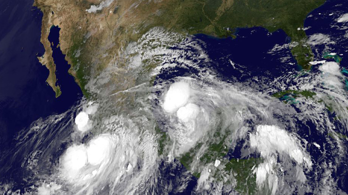
An image provided by NOAA taken at 2:45 a.m. EDT Sunday shows Hurricane Ingrid approaching from the Gulf of Mexico and Tropical Storm Manuel just off the western coast of Mexico.


AP

An image provided by NOAA taken at 2:45 a.m. EDT Sunday shows Hurricane Ingrid approaching from the Gulf of Mexico and Tropical Storm Manuel just off the western coast of Mexico.


An image provided by NOAA taken at 2:45 a.m. EDT Sunday shows Hurricane Ingrid approaching from the Gulf of Mexico and Tropical Storm Manuel just off the western coast of Mexico.


AP


From the east and the west, two storm systems are closing in on Mexico, bringing strong winds and heavy rains. Hurricane Ingrid is moving toward the country’s east coast in the Gulf of Mexico; Tropical Storm Manuel is closing in on the southwest coast in the Pacific Ocean.


People are evacuating areas of both coasts, fearing landslides and flash floods. The storms come on the heels of heavy rain that was being blamed for the deaths of more than a dozen people in the past week, Agence France-Presse reports.


Ingrid became the second hurricane of the Atlantic season on Saturday; packing 85 mph winds, it’s expected to continue to grow. A hurricane warning has been issued for Mexico’s gulf coast, from Cabo Rojo to La Pesca.


“We expect landfall to occur sometime on Monday in that area,” Michael Brennan of the National Hurricane Center in Miami says. “We do expect Ingrid to strengthen a little bit during the next couple of days, so we should see a hurricane making landfall in that area on Monday.”


As of Sunday morning, Ingrid was moving at 7 mph. According to the hurricane center’s latest projections, the storm could make landfall by noon on Monday. It is predicted to head in a mostly westerly direction into Mexico on Tuesday and Wednesday.


With winds measured at 70 mph, Manuel remains below the threshold for hurricane strength. But it could drop 10-15 inches of rain — and possibly much more in some spots — when it makes landfall, expected early Sunday.


News


Mexico Faces A One-Two Punch From Tropical Storms

Monday, July 29, 2013

Flossie: Hawaii braces for weakened tropical storm


(AP) — Residents and tourists across Hawaii are bracing for heavy rains and strong winds from Tropical Storm Flossie, while the system weakened as it approached the state.


National Weather Service officials said they expect people on the Big Island and Maui to see the brunt of the storm on Monday morning, with wind gusts up to 60 mph, possible flooding and waves up to 18 feet high.


Flossie could also bring mudslides, tornadoes and waterspouts, the forecasters said.


“For the folks on the Big Island and Maui, if you’re preparing your home, you should be rushing those preparations to completion,” said Michael Cantin, a warning coordination meteorologist with the National Weather Service in Honolulu.


“By the time you get up in the morning, the storm’s going to already be there and you won’t have any time,” he said.


The service on Sunday issued a tropical storm warning for Oahu, Hawaii’s most populous island with the city of Honolulu, to go along with previous warnings for the Big Island, Maui, Molokai and Lanai. The warning means the storm represents a threat to life and property.


Hawaii Gov. Neil Abercrombie signed an emergency proclamation in anticipation of the storm, allowing the state to use its disaster fund to pay for staff overtime, supplies and other resources. The proclamation also allows the state to call Hawaii National Guard members to duty, if necessary.


The U.S. Coast Guard also closed three ports — two on the Big Island where the storm is expected first and a third on Maui. College campuses and courts were also to be closed Monday on the Big Island.


Cantin said Sunday night that the system was weakening because winds in the higher levels of the atmosphere were beginning to move in more strongly, disrupting the circulation of the storm.


Cantin said wind gusts will likely be able to knock down power poles and blow away loose objects. He said people should be careful of trying to walk or drive across water if floods happen.


“It takes about 6 inches of water to knock you off your feet … 12 inches to move a vehicle,” he said.


The service also issued a tropical storm watch for Kauai and Niihau, a less severe notice asking people to make a plan and pay attention to see if things get worse.


Officials warned people to cancel beach trips, finish necessary storm preparations and evacuate if asked by local officials.


Mike McCartney, chief executive of the Hawaii Tourism Authority, said some airlines have begun to adjust flights and visitors should double-check plans.


Trails and campgrounds were also close on the Big Island, where state officials warned people to avoid forest areas until Flossie clears.


It’s not immediately clear which island faces the most danger, though the Big Island — the easternmost island in the archipelago — is likely the first in Flossie’s path. Flossie’s center was expected to pass near the Big Island and Maui on Monday morning and then south of Oahu several hours later on Monday evening into Tuesday morning.


The storm is expected to drop 6 inches to 10 inches of rain, with higher amounts on the eastern side and less on the western side of islands.


Waves of 12 to 18 feet are expected for the Big Island and Maui, with surf of 10 to 15 feet on other islands.


Despite the system weakening, the current forecast keeps Flossie as a tropical storm through Wednesday.


___


Oskar Garcia can be reached on Twitter at http://twitter.com/oskargarcia


___


Associated Press writer Christopher Weber in Los Angeles contributed to this report.


Associated Press


U.S. Headlines


Flossie: Hawaii braces for weakened tropical storm

Flossie: Hawaii braces for weakened tropical storm


(AP) — Residents and tourists across Hawaii are bracing for heavy rains and strong winds from Tropical Storm Flossie, while the system weakened as it approached the state.


National Weather Service officials said they expect people on the Big Island and Maui to see the brunt of the storm on Monday morning, with wind gusts up to 60 mph, possible flooding and waves up to 18 feet high.


Flossie could also bring mudslides, tornadoes and waterspouts, the forecasters said.


“For the folks on the Big Island and Maui, if you’re preparing your home, you should be rushing those preparations to completion,” said Michael Cantin, a warning coordination meteorologist with the National Weather Service in Honolulu.


“By the time you get up in the morning, the storm’s going to already be there and you won’t have any time,” he said.


The service on Sunday issued a tropical storm warning for Oahu, Hawaii’s most populous island with the city of Honolulu, to go along with previous warnings for the Big Island, Maui, Molokai and Lanai. The warning means the storm represents a threat to life and property.


Hawaii Gov. Neil Abercrombie signed an emergency proclamation in anticipation of the storm, allowing the state to use its disaster fund to pay for staff overtime, supplies and other resources. The proclamation also allows the state to call Hawaii National Guard members to duty, if necessary.


The U.S. Coast Guard also closed three ports — two on the Big Island where the storm is expected first and a third on Maui. College campuses and courts were also to be closed Monday on the Big Island.


Cantin said Sunday night that the system was weakening because winds in the higher levels of the atmosphere were beginning to move in more strongly, disrupting the circulation of the storm.


Cantin said wind gusts will likely be able to knock down power poles and blow away loose objects. He said people should be careful of trying to walk or drive across water if floods happen.


“It takes about 6 inches of water to knock you off your feet … 12 inches to move a vehicle,” he said.


The service also issued a tropical storm watch for Kauai and Niihau, a less severe notice asking people to make a plan and pay attention to see if things get worse.


Officials warned people to cancel beach trips, finish necessary storm preparations and evacuate if asked by local officials.


Mike McCartney, chief executive of the Hawaii Tourism Authority, said some airlines have begun to adjust flights and visitors should double-check plans.


Trails and campgrounds were also close on the Big Island, where state officials warned people to avoid forest areas until Flossie clears.


It’s not immediately clear which island faces the most danger, though the Big Island — the easternmost island in the archipelago — is likely the first in Flossie’s path. Flossie’s center was expected to pass near the Big Island and Maui on Monday morning and then south of Oahu several hours later on Monday evening into Tuesday morning.


The storm is expected to drop 6 inches to 10 inches of rain, with higher amounts on the eastern side and less on the western side of islands.


Waves of 12 to 18 feet are expected for the Big Island and Maui, with surf of 10 to 15 feet on other islands.


Despite the system weakening, the current forecast keeps Flossie as a tropical storm through Wednesday.


___


Oskar Garcia can be reached on Twitter at http://twitter.com/oskargarcia


___


Associated Press writer Christopher Weber in Los Angeles contributed to this report.


Associated Press


U.S. Headlines


Flossie: Hawaii braces for weakened tropical storm